
Hiking in Chile
Including Cajón del Maipo (San Francisco Glacier Trail), Cerro Castillo Circuit, and Cerro San Cristóbal. On the map.
The vibe
The landscape here feels raw and immense, defined by jagged granite spires and glaciers that dwarf any trail you walk. Late spring through early autumn offers the most stable weather for navigating these vast, wind-swept expanses. You will find a mix of well-trodden routes where you share the path with international trekkers and remote, quiet stretches that require a self-sufficient, DIY mindset.
You sort a park entry permit for most protected areas.

Cajón del Maipo (San Francisco Glacier Trail)
Santiago Metropolitan Region
Earth Science and Remote Sensing Unit , Lyndon B. Johnson Space Center / Wikimedia Commons (Public domain)
A rugged canyon and alpine valley hike just outside Santiago, leading through dramatic gorges and rocky ridges toward hanging glaciers. The trail showcases the raw, towering scale of the central Andes.
Access. About a 1.5 to 2-hour drive southeast of Santiago into the Andes foothills.
Notes. High sun exposure and changing mountain weather; start early in the morning.

Cerro Castillo Circuit
Aysen del General Carlos Ibanez del Campo Region
Manxuc / Wikimedia Commons (CC BY-SA 4.0)
A world-class multi-day alpine trek in Chilean Patagonia featuring jagged granite spires, turquoise glacial lagoons, hanging glaciers, and sweeping lenga forests. Often considered a wilder, less crowded alternative to Torres del Paine.
Access. Starts from Villa Cerro Castillo, reached via bus or car from Coyhaique along the Carretera Austral.
Notes. Permits and advance registration are required for camping along the circuit; weather can be extreme.

Cerro San Cristóbal
Santiago Metropolitan Region
Dario Alpern / Wikimedia Commons (CC BY-SA 3.0)
A beloved urban green space walk in Santiago offering well-maintained dirt trails and paved paths winding up to panoramic city overlooks and shrines.
Access. Located directly in Santiago, accessible via multiple metro stations and funiculars.

Cerro Toco
Antofagasta Region
Roberto Ortuzar / Wikimedia Commons (CC BY 3.0)
A high-altitude volcano hike in the Atacama Desert taking you above 5,600 meters with sweeping views of the Andes and salt flats. The trail follows an old mining road to the crater rim, offering a demanding but accessible high-altitude summit experience without technical climbing.
Access. Accessible via a 1.5-hour drive from San Pedro de Atacama, usually with a guided tour for acclimatization and 4x4 transport.
Notes. Severe altitude sickness risk; proper acclimatization over several days in San Pedro is essential.

Conguillío National Park (Sierra Nevada Trail)
Araucania Region
lautaroj / Wikimedia Commons (CC BY 2.0)
A stunning trek winding through ancient monkey puzzle (araucaria) forests, volcanic ash fields, and towering Andean peaks. The Sierra Nevada trail rewards hikers with panoramic overlooks of Lake Conguillío and the Llaima Volcano.
Access. Reached via road from Temuco or Curacautín; park entrance fee applies.
Notes. Trails may close in winter due to heavy snow; summer is the optimal season.

Dientes de Navarino
Magallanes and Chilean Antarctica Region
Janitoalevic / Wikimedia Commons (CC BY-SA 4.0)
The southernmost trek in the world, this multi-day route traverses the rugged, jagged peaks of Navarino Island. It offers an intense, remote wilderness experience with panoramic views of the Beagle Channel and the Antarctic landscape.
Access. Starts from Puerto Williams; requires ferry or flight access from Punta Arenas.
Notes. Advanced navigation skills required; weather is highly unpredictable and can change rapidly.

Magellanic Strait Coastal Trail
Magallanes and Chilean Antarctica Region
Fredlyfish4 / Wikimedia Commons (CC BY-SA 4.0)
A historic coastal walking route near Punta Arenas featuring windswept shorelines, Magellanic penguin colony overlooks, and sweeping views across the strait to Tierra del Fuego.
Access. Short drive north from downtown Punta Arenas.
Notes. Expect strong Patagonian winds and rapidly changing weather conditions.

Parque Nacional Chiloé
Los Lagos Region
Rjcastillo / Wikimedia Commons (CC BY-SA 4.0)
This coastal park on the western shore of Chiloé Island features trails through dense Valdivian rainforest that suddenly emerge onto wild, windswept Pacific beaches. It is a unique habitat for local wildlife and offers a moody, atmospheric coastal hiking experience.
Access. Accessible via ferry to Chiloé Island, then by road to the Cucao sector.
Notes. Trails can be extremely muddy; boardwalks are provided in sensitive areas.

Parque Nacional Lauca
Arica y Parinacota Region
BlackNose / Wikimedia Commons (CC BY 3.0)
Located in the high Andes, this park offers surreal landscapes featuring the Parinacota Volcano and the high-altitude Chungará Lake. Hikers can traverse volcanic plains and wetlands teeming with vicuñas and flamingos in a stark, breathtaking environment.
Access. Accessible via a 3-hour drive from Arica; hiring a local guide is highly recommended due to the extreme altitude and remote terrain.
Notes. Extreme altitude (above 4,000m); acclimatization is essential before attempting any hikes.

Parque Nacional Queulat
Aysen del General Carlos Ibanez del Campo Region
Earth Science and Remote Sensing Unit , Lyndon B. Johnson Space Center / Wikimedia Commons (Public domain)
Home to the famous Ventisquero Colgante (Hanging Glacier), this park features dense, humid rainforest trails that lead to viewpoints of massive waterfalls cascading from the ice. It is a premier destination for experiencing the wild, untamed beauty of the Aysén region.
Access. Located along the Carretera Austral; accessible by car or bus from Coyhaique or Puerto Cisnes.
Notes. Very high rainfall year-round; waterproof gear is mandatory.

Parque Nacional Radal Siete Tazas
Maule Region
Nelson Pérez / Wikimedia Commons (CC BY-SA 3.0)
Famous for its series of seven cascading pools and waterfalls carved into basaltic rock, this park offers spectacular canyon and forest walking. The trails lead hikers through lush vegetation to viewpoints overlooking the dramatic river drops.
Access. Accessible by road from Molina; the park has well-marked trails suitable for day hikers.
Notes. Swimming is prohibited in the pools to protect the ecosystem; trails are well-maintained.

Pichilemu Coastal Cliffs
O'Higgins Region
McKay Savage from London, UK / Wikimedia Commons (CC BY 2.0)
Rugged coastal walking along dramatic sandstone cliffs, hidden coves, and windswept beaches of the O'Higgins region. The path offers sweeping views of the Pacific Ocean and excellent birdwatching opportunities.
Access. Easily reached via regional buses or cars from Pichilemu, about a 3-hour drive southwest of Santiago.

Puyehue National Park (El Azufre Trail)
Los Lagos Region
eurimaco / Wikimedia Commons (CC BY-SA 3.0)
A volcanic trek through dense Valdivian temperate rainforest that opens up to high-elevation volcanic craters and thermal vents. Hikers traverse lush green valleys before climbing onto desolate volcanic slopes.
Access. Located off Ruta 215 east of Osorno; accessible by car with nearby hot spring resorts.
Notes. Rainforest sections can be muddy; waterproof footwear is essential.
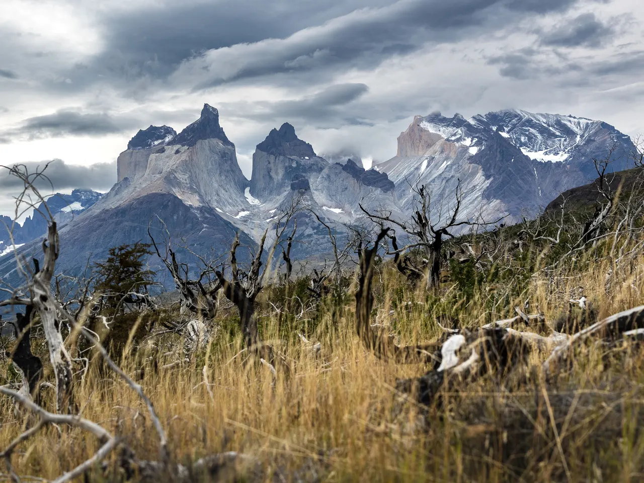
Torres del Paine National Park (W Trek)
Magallanes and Chilean Antarctica Region
Marek Piwnicki · Pexels
World-renowned alpine trekking route weaving past jagged granite towers, massive glaciers, and turquoise lakes. Expect challenging multi-day conditions, dramatic Patagonian weather, and some of the most iconic mountain scenery on Earth.
Access. Accessible via bus from Puerto Natales to the park entrances at Laguna Amarga or Pudeto. Advance booking for refugios or campsites is strictly mandatory.
Notes. Permits and campsites must be booked months in advance. Wind and weather can change dramatically in minutes.

Villarrica Volcano
Región de la Araucanía
Dmitry Kolesnikov from Moscow, Russia / Wikimedia Commons (CC BY 2.0)
An iconic active volcano hike near Pucón featuring a snow-and-ice ascent to a smoking crater rim. Climbers use crampons and ice axes under guide supervision, sliding down snow chutes on the descent.
Access. Depart from Pucón; guided ascents are mandatory and heavily regulated by local weather conditions.
Notes. Requires certified mountain guides, proper glacier gear, and favorable volcanic activity status.